Tập tin:Bermuda wv.jpg

Nội dung trang không được hỗ trợ ở ngôn ngữ khác.
Từ Wikivoyage

Bermuda_wv.jpg(800×600 điểm ảnh, kích thước tập tin: 335 kB, kiểu MIME: image/jpeg)

Tập tin này được lưu ở Wikimedia Commons và nó có thể được sử dụng ở các dự án khác. Lời miêu tả của tập tin tại trang mô tả được hiển thị dưới đây.

Miêu tả

Miêu tả
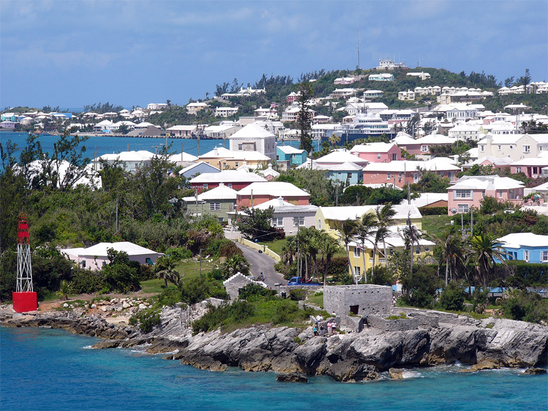
English: Residential suburb near the old St. George's Garrison, with "Town Cut Battery" or "Gate's Fort" in the foreground (with Cut Road behind it), on the northern side of the Town Cut shipping channel, and St. George's Town and harbour in the background, with Fort George on the peak of Mount Hill beyond, and a small ship is visible docked at Ordnance Island, off the town square]]. The Town Cut had been a minor channel, suitable only for small vessels to enter or exit the harbour, until dredged before the First World War. Before then, larger vessels had used the St. George's Channel between Paget Island and Governor's Island, which was watched over by Fort Paget (on Paget Island) and Smith's Fort (on Governor's Island). In the 19th Century, Fort Cunningham was erected on Paget Island, making all three of the earlier batteries redundant. Alexandra Battery (at Building Bay on St. George's Island, immediately to the north of Cut Battery) and St. David's Battery on St. David's Island were later added (there were also three other forts armed with coastal artillery batteries to the North-West of Building Bay: Fort St. Catherine's at St. Catherine's Point, and Fort Victoria and Fort Albert on Retreat Hill, to its rear). St. George's Town and the various forts and related military installations at the East End of Bermuda are together a United Nations Educational, Scientific and Cultural Organization's (UNESCO) World Heritage Site, the Historic Town of St George and Related Fortifications, Bermuda.[1][2]
Ngày 24 tháng 8 năm 2006 (ngày tải lên ban đầu)
Nguồn gốc Tác phẩm được tạo bởi người tải lên
Tác giả (WT-en) Legrospaumé tại Wikivoyage Tiếng Anh
Vị trí máy chụp hình32° 22′ 44,66″ B, 64° 39′ 44,88″ T  Heading=270° Kartographer map based on OpenStreetMap.Xem hình này và các hình ảnh lân cận trên: OpenStreetMapinfo

References

  1. Bermuda Forts 1612–1957, Dr. Edward C. Harris, The Bermuda Maritime Museum Press, The Bermuda Maritime Museum, P.O. Box MA 133, Mangrove Bay, Bermuda MA BX, ISBN 0-921560-11-7
  2. UNESCO World Heritage Centre: Historic Town of St George and Related Fortifications, Bermuda

Giấy phép

Public domain Tác phẩm này đã được tác giả của nó, (WT-en) Legrospaumé tại Wikivoyage Tiếng Anh, phát hành vào phạm vi công cộng. Điều này có hiệu lực trên toàn thế giới.
Tại một quốc gia mà luật pháp không cho phép điều này, thì:
(WT-en) Legrospaumé tại Wikivoyage Tiếng Anh cho phép tất cả mọi người được quyền sử dụng tác phẩm này với bất cứ mục đích nào, không kèm theo bất kỳ điều kiện nào, trừ phi luật pháp yêu cầu những điều kiện đó.

Nhật trình tải lên đầu tiên

This file was imported from Wikivoyage en.
Trang miêu tả gốc từng tồn tại ở đây. Tất cả các tên người dùng sau là tên người dùng tại en.wikivoyage-old.
  • 2006-08-24 12:07 (WT-en) Legrospaumé 800×600 (343391 bytes) Bermuda (Import from wikitravel.org/en)

Chú thích

Ghi một dòng giải thích những gì có trong tập tin này

Khoản mục được tả trong tập tin này

mô tả

32°22'44.659"N, 64°39'44.881"W

heading Tiếng Anh: 270 độ

checksum Tiếng Anh

3d64e6bffa0716525fba5dba42b76fb85d2e81f4

600 pixel

Lịch sử tập tin

Nhấn vào ngày/giờ để xem nội dung tập tin tại thời điểm đó.

Ngày/GiờHình xem trướcKích cỡThành viênMiêu tả
hiện tại02:09, ngày 9 tháng 1 năm 2013Hình xem trước của phiên bản lúc 02:09, ngày 9 tháng 1 năm 2013800×600 (335 kB)MGA73bot2{{BotMoveToCommons|en.oldwikivoyage|year={{subst:CURRENTYEAR}}|month={{subst:CURRENTMONTHNAME}}|day={{subst:CURRENTDAY}}}} == {{int:filedesc}} == {{Information |description=Bermuda |date={{Date|2006|8|24}} (original upload date) |source={{Own}}<BR />{{...

Trang sau sử dụng tập tin này:

Sử dụng tập tin toàn cục

Những wiki sau đang sử dụng tập tin này: